Spatial Units, Building Logbook and Technical Data
Hereunder a simplified model showing the high level relationship between the Land Admnistration (LA) concepts and the AEC technical data.
erDiagram
    LA_Party
    LA_BAUnit
    LA_RRR
    LA_SpatialUnit {
        externalIDType id PK
    }
    spatialUnit_JunctionWith_LA_spatialUnit {
        uuid id
        uuid spatialUnitId
        string external_id UK
    }
    spatialUnit {
        uuid id PK
    }
    dataBundle ["dataBundle: technical Data (e.g. IFC's)"] {
        uuid id PK
    }

    spatialUnitBundleUnit {
        uuid id PK
        uuid spatialUnitId FK
        uuid bundleId FK
        uuid bundleUnitId FK
    }

    bundleUnit {
        uuid5   bundleunit_id PK  "The Id as a hash of all columns except unitJson"
        int     bundle_id "The Id of the bundle"
        uuid    unit_id "The Id if the Object "
        string  unitType "The type of the Object (e.g. IfcSpatiaZone)"
        string  unitName "The name of the object (e.g. Apartment 01-09)"
        string  relationship_type "The type of the relationship (e.g. 'IfcRelAggregates)"
        uuid    parent_id "The Id of the Parent"
        string  parent_type "The type of the parent (e.g. 'IfcBuildingStorey')"
        json    unitJson "Information that is specific to the type"
    }

    LA_Party }|--|{ LA_RRR : ""
    LA_RRR }|--|| LA_BAUnit : ""
    LA_BAUnit }|--|{ LA_SpatialUnit : ""
    DBL_Digital_Building_LogBook ||..|{ LA_SpatialUnit : ""
    spatialUnit_JunctionWith_LA_spatialUnit }|--|| LA_SpatialUnit : ""
    spatialUnit_JunctionWith_LA_spatialUnit }|--|| spatialUnit : ""
    spatialUnit ||--|{ spatialUnitBundleUnit: ""
    bundleUnit  ||--|{ spatialUnitBundleUnit: ""
    dataBundle ||--|{ bundleUnit: ""
LA_Party, LA_RRR, LA_BAUnit, LA_SpatialUnit and DBL_Digital_Building_LogBook are placeholders for external concepts that are highly relevant for the Use Cases supported / enabled by the D4SU platform but are not included in the scope of the D4SU platform and supporting database.
LA_Party, LA_RRR, LA_BAUnit, LA_SpatialUnit are part of the Land Administration Domain Model (LADM) ISO 19152-1:2024.
The initial focus of LADM is the Cadastral Registration of LAND (with a large and diverse meaning of any 'spatial extent that is defined by RRRs [via baunit] and encompass the surface of the earth, strata, sub-strata or the marine environment'). But as noted in the introduction to D4SU, the concept can be applied to BAUnit that are not related to the Cadastral Registration such as e.g., Energy Effiency of Buidlings or Housing Regulation.
According to its Definition, the Digital Building Logbook (DBL) is a common repository for all relevant building data. It facilitates transparency, trust, informed decision making and information sharing within the construction sector, among building owners and occupants, financial institutions and public authorities. The Technical guidelines for digital building logbooks has favored options where:
- The information is “pulled” by the DBL from the data source
- Storage in the DBL would rely on CKAN. The Comprehensive Knowledge Archive Network (CKAN) is an open-source open data portal for the storage and distribution of open data.
The Figure 32: Properties for buildings extracted from the Technical guidelines for digital building logbooks report and shown hereinunder makes clear the the DBL will benefit from readily available and accessible information from technical information such as provided by BIM/IFC or other source that would be supported by the D4SU.
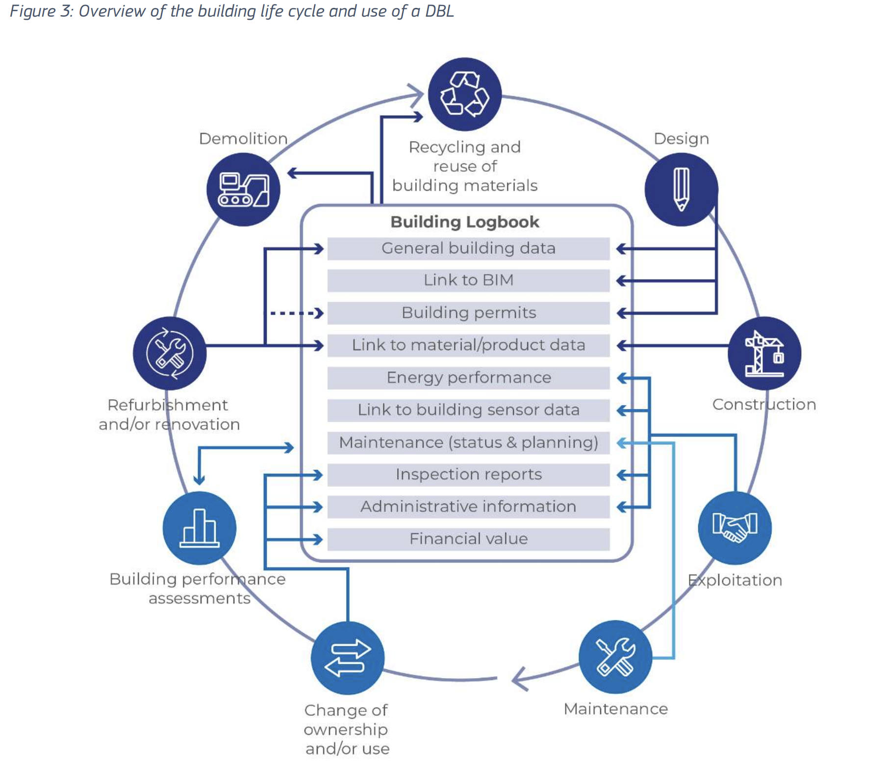
The purpose of the D4SU platform is to enable the provision of an API to provide data based responses to request for information (technical data) from an administrative process (possibly supported/faciliated by the DBL).
Typically, SpatialUnits will include:
- The land on which the building is built (Cadastral Ground Parcel)
- The Building itself (Whole Building)
- The Commmon Parts (or Shared Unit)
- The Private Parts (Private Building Unit) whether used for Housing, Commercial, Office, Industrial or Parking purpose
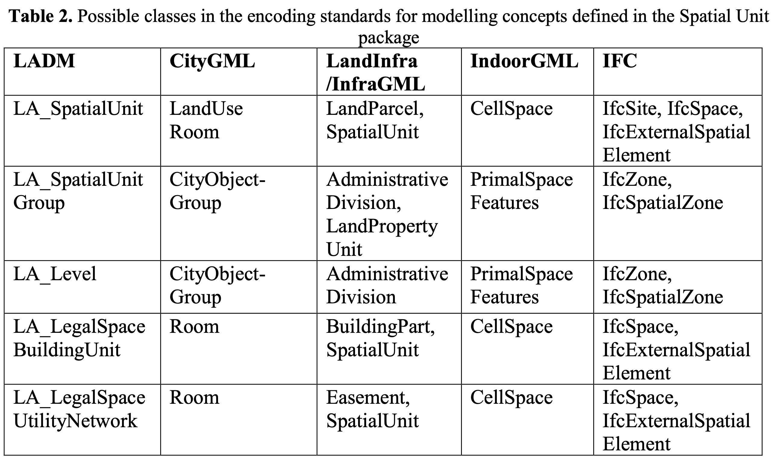
The following Table extracted from the paper Evaluation of the International 3D Geospatial Data Models and IFC Standard for Implementing an LADM-based 3D Digital Cadastre provide some suggestions on the level of the link between the LADM Spatial Unit and concepts from other source (CityGML, IFC, IndoorGML, InfraGML).
What we refer to as a SpatialUnit is actually any entry of the first column (hence: SpatialUnit, SpatialUnitGroup, Level (Storey), ...).
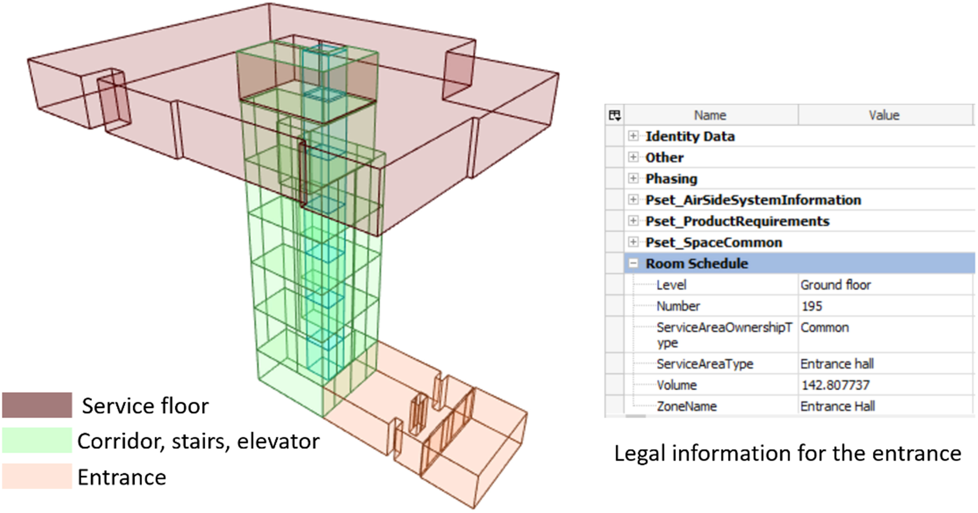
The paper Mapping private, common, and exclusive common spaces in buildings from BIM/IFC to LADM. A case study from Saudi Arabia brings an in depth view of the relationships between the technical data of the IFC model and the Spatial Units of LADM for a variety of cases. We show hereunder two views, one for apartments and one for common parts that illustrates capabilities that will need to be supported by the d4SU platform.
View of Spaces corresponding to apartements

View of Spaces corresponding to Common parts
On the above figures, Spatial Units are limited to the representations (3D Spaces), whereas, more may be needed and adding all relevant construction and distribution elements will be proposed instead.